This 139,062 hectare landscape stretches from the South Australian Border in the west along the Murray River down to Nyah in the east. It is one of the more heavily populated areas in the region, encompassing Merbein, Robinvale, Piangil as well as parts of Mildura, Red Cliffs, Boundary Bend and Nyah.
The Murray River forms the northern boundary of the Victorian Mallee region and while the river is the statutory responsibility of NSW, Victoria is responsible for the management of its southern floodplain from the 1881 winter level water mark. Within the Mallee this represents some 731 kilometres of Murray River Frontage (Figure 41).
Approximately 72 percent of the landscape is public land, including: Murray-Kulkyne Park, Nyah-Vinifera Park, Kings Billabong Park, parts of Murray Sunset and Hattah-Kulkyne National Parks, and numerous smaller reserves. Agriculture, both irrigated and dryland, represents the other primary land use within the area (61).
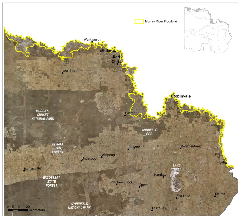
Figure 41 | Murray River Floodplain Local Area.
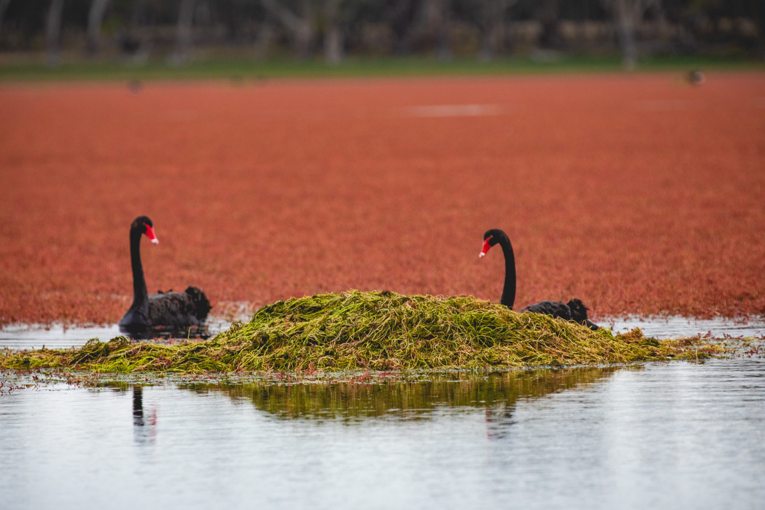
The area is important for the high diversity and quality of riparian and aquatic habitat it provides, supporting significant populations of rare and threatened species. The Murray River Floodplain Local Area encompasses 15 sub-management units to support targeted planning and delivery processes within the larger landscape where required (see Figure 40). These units align with Waterway Management Units (WMUs) applied by the Mallee Waterway Strategy; providing for monitoring and reporting efficiencies.
Five other Local Areas adjoin the Murray River Floodplain: Murray Sunset Complex in the north west of the region and at Hattah; Murray Scroll Belt between Merbein and the South Australian Border; Cardross-Koorlong near Mildura; Annuello–Wandown in the north east of the region; and Agricultural Land along most of the remaining boundary.
(61) See Local Area 9 for further detail on associated agricultural land values and priorities.
Native vegetation has been retained across 92 percent of the landscape. Of this, 25 percent is classified as Endangered (Riverine Chenopod Woodland EVCs) and 42 percent as Vulnerable (primarily Lignum Shrubland (12%), Lignum Swampy Woodland (11%) and Semi-arid Woodland (5%) EVCs).
Vegetation on frontages adjacent to the River is comprised predominantly of River Red Gum communities, with broader floodplain further characterised by Black Box woodlands, lignum shrublands and grasslands. The floodplain area adjoins large, open areas of semi-arid grasslands and chenopod shrublands.
State-wide modelling identifies 112,856 hectares (81% of total area) of habitat occurring within this landscape as being of the highest ecological value to Victoria (top 20%) and therefore a priority for protection and enhancement (see Appendix 8).
Some 15,435 hectares of waterways occur across the area, with 75 wetlands (6,695 ha) and 65 reaches (5,059 ha) identified as a priority for management. Nine of the region’s 16 sites listed on the Directory of Important Wetlands Australia (DIWA) are located within this area; Lindsay and Wallpolla Islands, Lake Wallawalla, Kings Billabong Wetlands, Lake Ranfurly, Belsar Island, Heywoods Lake, Hattah Lakes, and Major Mitchell’s Lagoon.
Two of the Murray Darling Basin Authority’s six Living Murray ‘icon’ sites, selected for their high ecological value and cultural significance, occur in the area: the Lindsay, Wallpolla and Mulcra Island components of the Chowilla Floodplain; and the Hattah Lakes. The Hattah-Kulkyne Lakes System, a series of perennial and intermittent freshwater lakes fed mainly from the Murray River via Chalka Creek, also includes 12 lakes declared as Wetlands of International Importance under the Ramsar Convention.
Waterways within the area provide critical habitat for many migratory birds listed in international agreements (i.e. JAMBA, CAMBA and ROKAMBA); and for several fish species included in the Lowland Riverine Fish Community of the Southern Murray-Darling Basin, which is listed as threatened under the FFG Act.
In total, 249 species listed as threatened at a federal and/or state level have been recorded as occurring within this Local Area since 1990; comprising of 56 birds, nine reptiles, five fish, three mammals, one amphibian and 175 plants. Habitat distribution models identify that the area is of particular importance to the conservation of three threatened plant species (Soda Bush, Low Hibiscus and Velvet-Leaf Hibiscus) due to the proportion of their Victorian range (i.e. >50%) contained in this landscape. Habitat within the area also supports species included in the EPBC listed (Endangered) Mallee Bird Community of the Murray Darling Depression Bioregion (e.g. Regent Parrot).
Species identified as having local significance and/or cultural importance include Darling and Garland Lilies, Emu Bushes, Desert Groundsel, Winged Peppercress, Fat-tailed Dunnart, Carpet Python, Red-naped Snake, Regent Parrot, Barking Owl, Australian Painted Snipe, and Murray Cod (62).
(62) A complete list of species identified as a priority for management will be provided in the associated Murray River Floodplain Local Area Action Plan.
The high number of cultural sites throughout the Murray floodplain is unique in Victoria, both for their concentration and diversity. Aboriginal people have inhabited this area for tens of thousands of years on a relatively permanent basis with the landscape rich in both tangible and intangible culture and heritage.
The area holds cultural importance to several Traditional Owner groups identifying connections to Country across the landscape. There is one Registered Aboriginal Party, First People of the Millewa Mallee Aboriginal Corporation, that has statutory responsibilities for managing Aboriginal Cultural Heritage on Country in this area, specifically from the South Australian Border to Iraak (see Figure 2).
Integrating Traditional Owner cultural values, practices, knowledge and objectives into the management of the landscape is considered a high priority to facilitate increased participation in local NRM and support the broader process of self-determination.
Recreation and tourism is an important use of frontages along the length of the Murray River and floodplains; favoured by locals and visitors alike for the numerous river access points and camping spots that provide recreational opportunities such as fishing, canoeing, bird watching and 4WD tracks. Potential impacts such as rubbish dumping, right of unfettered access (e.g. long term impact to river banks), and fire are a concern for natural and cultural values management.
Community interest in conservation in this area is high, with volunteerism and participation in education- based activities facilitated by proximity to the region’s larger population centres. Active groups include Landcare (Millewa-Carwarp, Yelta, Cabarita, Robinvale-Annuello, Kooloonong-Natya, Nyah-West, Lindsay Point, Mallee Conservation and Mallee Bushland Care), Mid-Murray Field Naturalists, BirdLife Mildura, Friends of Merbein Common, Mildura 4WD Club, Murray Darling Association, Murray Lower Darling Rivers Indigenous Network, OzFish Unlimited Sunraysia Chapter, OzFish Unlimited Euston-Robinvale Chapter, and Sunraysia Bushwalkers Inc.
Management actions that protect and enhance the significant values of this Local Area will provide for integrated, landscape-scale outcomes that also deliver against the whole-of-region medium-term (6-year) outcomes targets identified for our Biodiversity, Waterways, Agricultural Land, Culture and Heritage, and Community Capacity for NRM assets. Table 14 provides an overview of priority management actions and targets to be implemented within the area, and the local stakeholders that will contribute to their delivery (see Appendix 7 for complete list of Priority Management Directions).
A separate Murray River Floodplain Local Area Action Plan will provide further detail on stakeholder interests, existing programs/activities, and future investment priorities. The plan will be reviewed annually in consultation with stakeholders to ensure currency and inform ongoing investment/delivery priorities.