This 762,748 hectare landscape includes Wyperfeld National Park, Big Desert Wilderness Park and Big Desert State Forest. Collectively these areas form the largest remnant of uncleared native vegetation in the agricultural areas of south-eastern Australia. The Big Desert Wilderness Park is the largest of Victoria’s 22 wilderness areas, while the Big Desert State Forest is the largest of Victoria’s State Forest areas.
Approximately 92 percent of the landscape is public land, with dryland agriculture representing the other primary land use within the area (74).
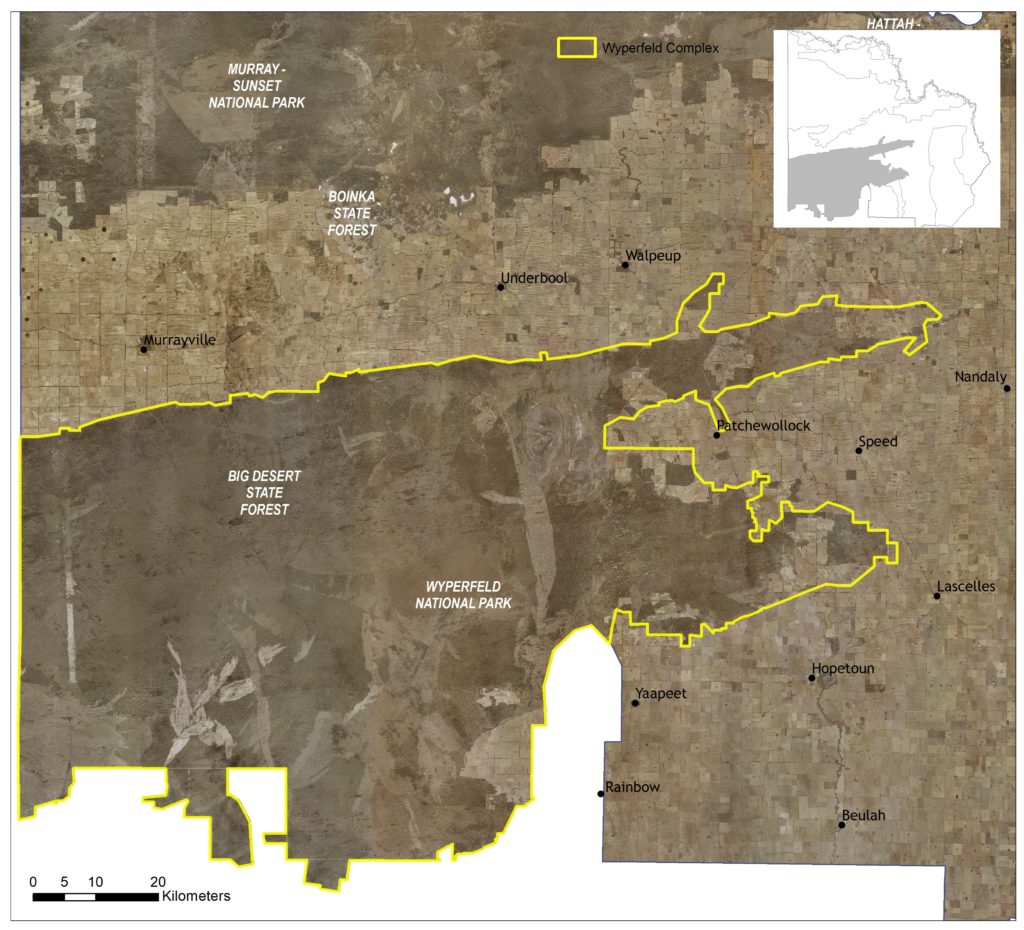
The Wyperfeld Complex Local Area (Figure 56) encompasses four sub-management units to support targeted planning and delivery processes within the larger landscape where required (see Figure 40). These units broadly align with conservation assets applied by the Mallee Parks Conservation Action Plan, encompassing Wyperfeld/Big Desert Dunefields (Heathlands), Outlet Creek and Wirrengren Plains (Semi-arid Woodland), Bronzewing Dunefields (Mallee Triodia), and Wathe Dunefields (Mallee Triodia). The Outlet Creek and Wirrengren Plains sub-management units also align with the ‘Wyperfeld’ Waterway Management Units (WMUs) applied by the Mallee Waterway Strategy.
Two other Local Areas adjoin the Wyperfeld Complex: North Wimmera Creeklines in the south; and Agricultural Land along most of the remaining boundary.
(74) See Local Area 9 for further detail on associated agricultural land values and priorities.
Around 93 percent (712,569 ha) of native vegetation has been retained across the landscape. Overall, the vegetation occurring with the area classified as Vulnerable (3%), or Endangered (0.4%) is relatively low. The most common vegetation types across this area include: Ridged Plains Mallee, Parilla Mallee, Intermittent Swampy Woodland/Riverine Grassy Woodland Complex, Salt Paperbark Woodland/Samphire Shrubland Mosaic, Woorinen Mallee and Semi-arid Woodland.
It does however include three EPBC listed ecological communities, the Endangered Buloke Woodlands of the Riverina and Murray-Darling Depression Bioregions, and the Critically Endangered: Plains Mallee Box Woodlands of the Murray Darling Depression and Riverina Bioregions, and the Natural Grasslands of the Murray Valley Plains.
State-wide modelling identifies 291,975 hectares (38% of total area) of habitat occurring within this area as being of the highest ecological value to Victoria (top 20%) and therefore a priority for protection and enhancement (see Appendix 8).
Some 5,473 hectares of ephemeral waterways occur within the Outlet Creek-Wirrengren Plain sub-management unit area, with two wetlands (4,573 ha) and one reach (131 ha) identified as a priority for management.
This encompasses a relatively small (67 km) section of Outlet Creek, a north flowing intermittent stream of the Wimmera River. Outlet Creek is generally dry, filled by overflowing floodwaters from Lake Albacutya (located in the Wimmera region). Wimmera River’s listing as a Victorian Heritage River includes the Outlet Creek section.
Wetlands linked to and derived from Outlet Creek are included in the Wimmera River’s listing in the National Directory of Important Wetlands due to the relative uniqueness of the land locked drainage system, and significant ecology it supports for rare and threatened species. The 5,000 hectare Wirrengren Plain, representing the last lake into which the Wimmera River Flows, was last flooded in 1874.
In total, 104 species listed as threatened at a federal and/or state level have been recorded as occurring within this Local Area since 1990; comprising of 29 birds, seven reptiles, two mammals, one insect and 65 plants.
Habitat distribution models identify that the area is of particular importance to the conservation of two listed plant species (Shining Spyridum and Azure Sun-orchid) and four reptiles (Mallee Worm Lizard, Masters’ Snake, Rosenberg’s Goanna, and the Heath Skink) due to the proportion of their Victorian range (i.e. >50%) contained in this landscape.
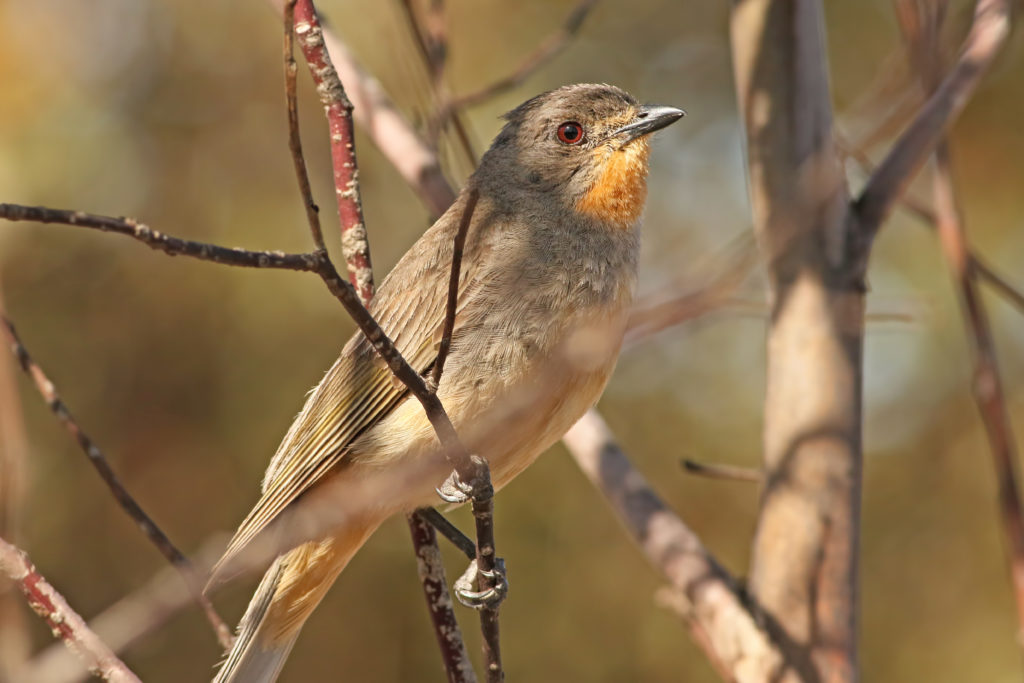
The area is also important to the conservation of several species included in the EPBC listed (Endangered) Mallee Bird Community; including, Malleefowl, Black-eared Miner, Western Whipbird, Mallee Emu-wren, and Red-lored Whistler.
Species identified as having local significance and/or cultural importance include Buloke Woodlands, Semi-arid Woodlands, Mallee Worm Lizard, Pink Cockatoo, and the Mallee Bird community.
This landscape is recognised as having high value to Traditional Owners, with a large number of cultural sites recorded across the landscape. Barengi Gadjin Land Council (BGLC) has statutory responsibilities for managing Aboriginal Cultural Heritage on Country across this Landscape. BGLC also participate in the management of some parks and reserves occurring in this landscape, under a Co-operative Management Agreement with the State.
Integrating Traditional Owner cultural values, practices, knowledge and objectives into the management of the landscape is considered a high priority to facilitate increased participation in local NRM and support the broader process of self-determination.
The parks within this Local Area are popular for self-sufficient 4WD touring and camping with extensive track networks and camp sites providing unique remote travel experiences. Recreational pressure can contribute to impacts including littering, track proliferation, firewood collection, soil compaction and site erosion, a concern for natural and cultural values management. However, these impacts are relatively low in this Local Area and depend on the accessibility, popularity and sensitivity of the site.
Active community- based groups in the area include Landcare (Hopetoun, Rainbow and District, Mallee and Weeah groups), Friends of Wyperfeld, Mildura 4WD Club, Murray Darling Association, Victorian Malleefowl Recovery Group and Sunraysia Bushwalkers Inc.
Management actions that protect and enhance the significant values of this Local Area will provide for integrated, landscape-scale outcomes that also deliver against the whole-of-region medium-term (6-year) outcomes targets identified for our Biodiversity, Waterways, Agricultural Land, Culture and Heritage, and Community Capacity for NRM assets. Table 20 provides an overview of priority management actions and targets to be implemented within the area, and the local stakeholders that will contribute to their delivery (see Appendix 7 for complete list of Priority Management Directions). A separate Wyperfeld Complex Local Area Action Plan will provide further detail on stakeholder interests, existing programs/activities, and future investment priorities.
The plan will be reviewed annually in consultation with stakeholders to ensure currency and inform ongoing investment/delivery priorities.