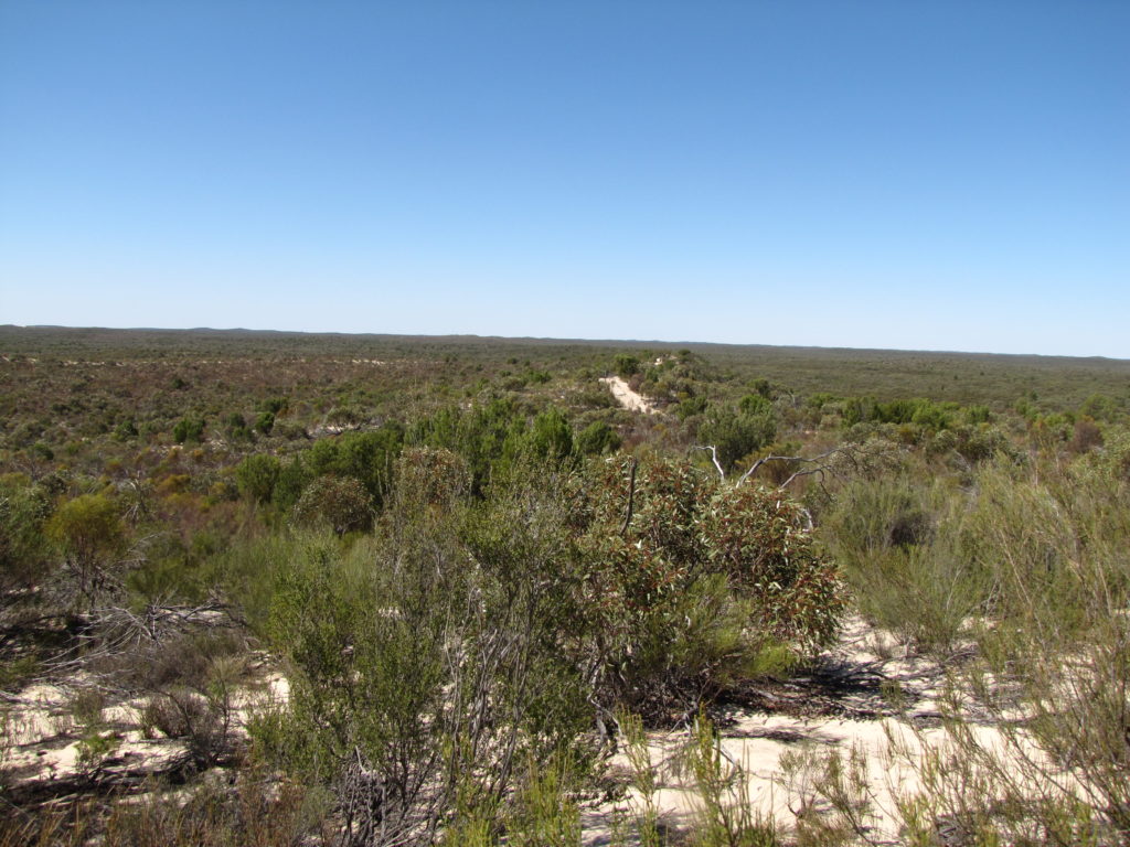
This 872,276 hectare landscape encompasses Victoria’s largest National Park (Murray-Sunset – 677,000 ha); one of the few remaining semi-arid regions in Australia which has remained relatively unmodified by human activity.
Approximately 83 percent of the landscape is public land, including: Murray Sunset National Park, Yarrara Flora and Fauna Reserve, most of Hattah Kulkyne National Park, Berrook and Berribee State Forests, and numerous smaller reserves. Agriculture, mostly dryland, represents the other primary land use within the area (68).
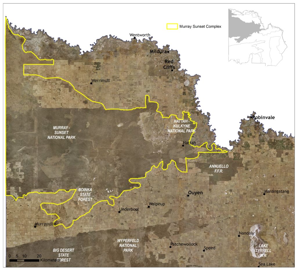
The Murray Sunset Complex Local Area (Figure 49) encompasses four sub-management units to support targeted planning and delivery processes within the larger landscape where required (see Figure 40). These units broadly align conservation assets applied by the Mallee Parks Conservation Action Plan, encompassing Northwest Woodlands (Semi-arid Woodlands), Murray-Sunset Dunefields (Mallee Triodia), Raak Plain (Inland Saline Soak), and Pink Lakes (mixed). They also encompass two Waterway Management Units (WMUs) applied by the Mallee Waterway Strategy: Pink Lakes and Raak Plain.
Four other Local Areas adjoin the Murray Sunset Complex: Murray River Floodplain in the north west of the region and at Hattah; Murray Scroll Belt in the north west; Annuello–Wandown in the north east of the region; and Agricultural Land along most of the remaining boundary.
(68) See Local Area 9 for further detail on associated agricultural land values and priorities.
Around 85 percent (747,055 ha) of native vegetation has been retained across the landscape, with a significant proportion (91%) found on public land. Some 27 percent of the vegetation occurring with the area is classified as Vulnerable, consisting primarily of Woorinen Mallee (16%), Semi-arid Woodland (9%) and Chenopod Mallee (5%) EVCs.
This includes three EPBC listed ecological communities: the Endangered Buloke Woodlands of the Riverina and Murray-Darling Depression Bioregions; and the Critically Endangered Plains Mallee Box Woodlands of the Murray Darling Depression and Riverina Bioregions, and Natural Grasslands of the Murray Valley Plains.
Yarrara Flora and Fauna Reserve, Meringur and Mallanbool Reserves collectively contain the largest remnants of Belah Woodlands in Victoria.
The largely intact habitat provided by the overall Murray Sunset Complex landscape also provides important links to Hattah-Kulkyne Lakes and Annuello Flora and Fauna Reserve.
State-wide modelling identifies 365,582 hectares (42% of total area) of habitat occurring within this area as being of the highest ecological value to Victoria (top 20%) and therefore a priority for protection and enhancement (see Appendix 8).
There are 4,300 hectares of saline wetlands systems located within the Pink Lakes and Raak Plain sub- management units. The Pink Lakes System represents an outstanding example of a boinka landform (one of only four found in north western Victoria) and is listed on the national Directory of Important Wetlands. The area is frequented by migratory bird species listed in international migratory bird agreements between Australia and Japan (JAMBA), China (CAMBA) and South Korea (ROKAMBA).
Raak Plain, the largest (~400 square kilometres) and most active natural groundwater discharge in Victoria, is also listed in the Directory of Important Wetlands. The system of saline lakes and gypseous saltmarsh plains surrounded by dunes and ridges is of high conservation value owing to the diversity of vegetation communities and the presence of rare plant species.
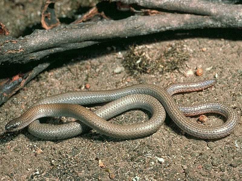
In total, 164 species listed as threatened at a federal and/or state level have been recorded as occurring within this Local Area since 1990; comprising 37 birds, seven reptiles, two fish, three mammals and 155 plants. Habitat distribution models identify that the area is of particular importance to the conservation of the Black-eared Miner, Mallee Emu-wren, Beaked Gecko, and several threatened plant species (e.g. Buttercup Pennywort) due to the proportion of their Victorian range (i.e. >50%) contained in this landscape.
Habitat within the area is also critical to the persistence of the EPBC listed (Endangered) Mallee Bird Community of the Murray Darling Depression Bioregion.
Species identified as having local significance and/or cultural importance include Semi-arid Woodlands, Buloke Woodlands, Mallee Ningui, Desert Skink, Mallee Worm Lizard, White-browed Treecreeper, and the Threatened Mallee Bird Community (Mallee Emu-wren, Black-eared Miner, Red-lored Whistler, Striated Grasswren, Regent Parrot, Malleefowl) (69).
(69) A complete list of species identified as a priority for management will be provided in the associated Murray River Floodplain Local Area Action Plan.
This landscape is recognised as having high value to Traditional Owners, with a large number of cultural sites recorded. First People of the Millewa Mallee Aboriginal Corporation has statutory responsibilities for managing Aboriginal Cultural Heritage on Country across the northern sections of the area (see Figure 2).
Integrating Traditional Owner cultural values, practices, knowledge and objectives into the management of the landscape is considered a high priority to facilitate increased participation in local NRM and support the broader process of self-determination.
This Local Area’s parks and reserves are popular for day use recreation, with activities including 4WD tracks, camping bushwalking and bird watching. Off-road trailbike riding and 4WD is a concern for natural and cultural values management.
Millewa-Carwarp, Lindsay Point, Mallee, Murrayville and Weeah Landcare Groups, BirdLife Mildura, Mid-Murray Field Naturalists, Mildura 4WD Club, Murray Darling Association, Murray Lower Darling Rivers Indigenous Network, Victorian Malleefowl recovery Group (VMRG) and Sunraysia Bushwalkers Inc. represent the key community based NRM groups active across parts of the landscape.
Management actions that protect and enhance the significant values of this Local Area will provide for integrated, landscape-scale outcomes that also deliver against the whole-of-region medium-term (6-year) outcomes targets identified for our Biodiversity, Waterways, Agricultural Land, Culture and Heritage, and Community Capacity for NRM assets. Table 17 provides an overview of priority management actions and targets to be implemented within the area, and the local stakeholders that will contribute to their delivery (see Appendix 7 for complete list of Priority Management Directions).
A separate Murray Sunset Complex Action Plan will provide further detail on stakeholder interests, existing programs/activities, and future investment priorities. The plan will be reviewed annually in consultation with stakeholders to ensure currency and inform ongoing investment/delivery priorities.